
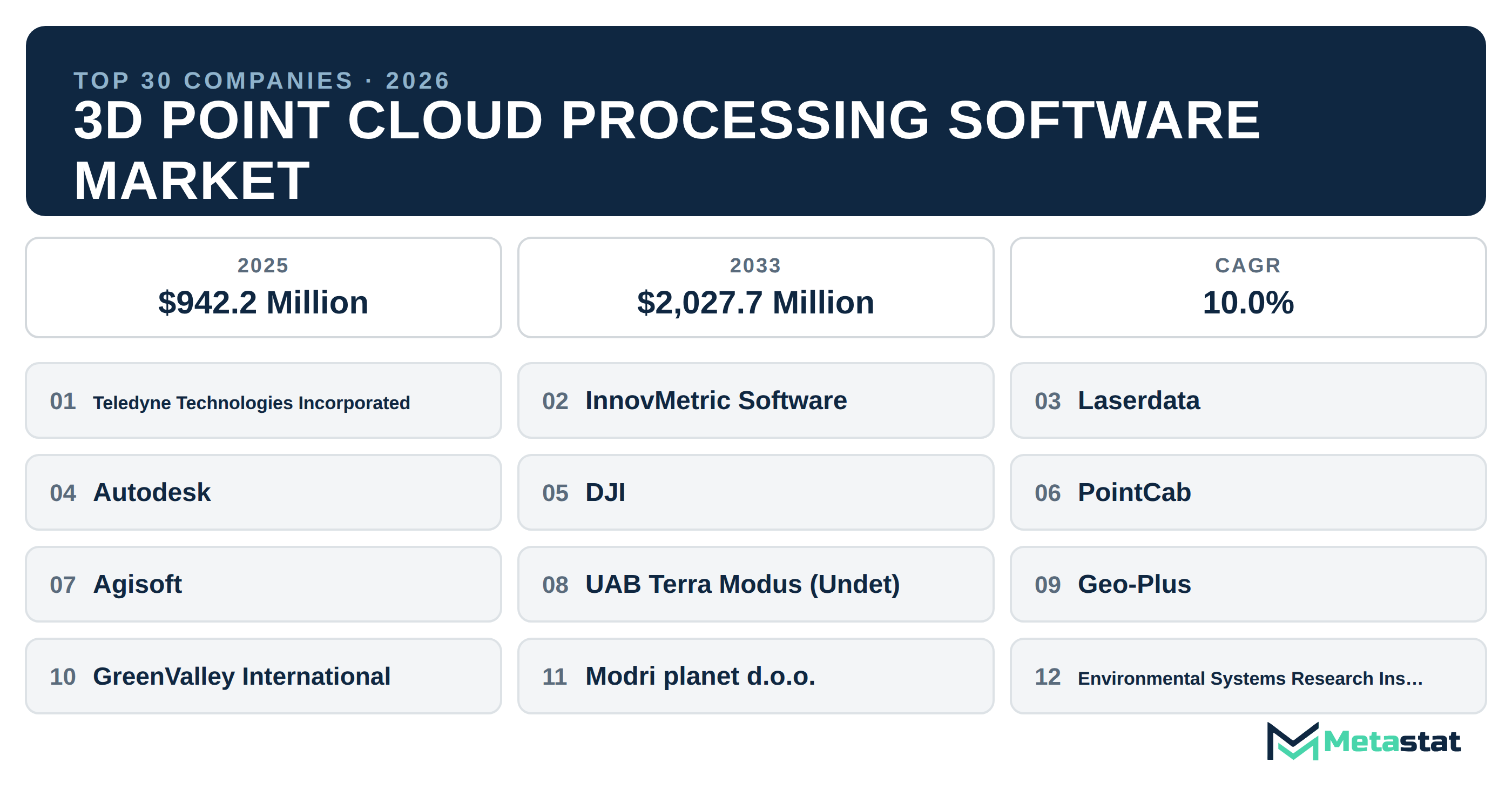
Explore the top 30 companies in the 3D Point Cloud Processing Software industry, highlighting their offerings and innovations.
The 3D Point Cloud Processing Software industry transforms raw data from LiDAR and imaging technologies into valuable insights for various applications. Industries such as construction, engineering, and geospatial services rely on these software solutions to enhance project workflows and improve accuracy. With the ongoing trends of automation and digitalization, the demand for effective software solutions is rising. For more details, consult the 3D Point Cloud Processing Software market size and forecast report.
Top 10 3D Point Cloud Processing Software Trends
Inline metrology moves onto the production line
Inline metrology systems integrate directly into production processes, allowing real-time quality assurance without interrupting workflow. This shift enhances product quality and reduces waste. Companies adopting inline systems gain competitive advantages through efficiency and precision.
Cloud-based solutions gain traction
Cloud-based 3D point cloud processing solutions allow for easier data sharing and collaboration across teams. This trend supports remote work and improves project turnaround times. Users benefit from the flexibility and scalability provided by cloud solutions.
AI enhances data processing capabilities
Artificial intelligence applications in 3D point cloud processing streamline tasks such as classification and feature extraction. AI-driven tools increase accuracy and reduce manual intervention. Companies leveraging AI can optimize resource allocation and improve decision-making processes.
Integration with GIS becomes standard
As geographic information systems (GIS) become increasingly interconnected with 3D point cloud solutions, users benefit from enhanced spatial analysis capabilities. This integration supports more effective planning and management across various industries, improving overall project outcomes.
Emphasis on user-friendly interfaces
User experience remains a priority for software developers, focusing on intuitive interfaces that simplify complex processes. Enhanced usability reduces training time and encourages wider adoption of advanced technologies among users with varying technical backgrounds.
Mobile solutions expand accessibility
Mobile applications for 3D point cloud processing enable field workers to access, manipulate, and share data on the go. This increased accessibility improves data-driven decision-making in real-time operations, enhancing responsiveness to changing conditions.
Real-time collaboration tools emerge
With the rise of remote work, real-time collaboration tools for 3D point cloud processing enable teams to work together from different locations. These tools enhance communication and streamline project workflows, benefiting project timelines and quality.
Focus on sustainability practices
As environmental concerns grow, companies are emphasizing sustainability in their practices and technologies. 3D point cloud processing software can aid in resource management and environmental assessments, aligning with corporate sustainability goals.
Regulatory compliance drives innovation
Increased regulatory scrutiny in industries such as construction and environmental management drives the adoption of advanced 3D point cloud technologies. Companies must invest in compliant solutions to meet evolving standards and avoid penalties.
3D Point Cloud Processing Software Companies Profiled
1. Teledyne Technologies Incorporated
Founded: 1960
Teledyne Technologies Incorporated provides advanced imaging systems and software solutions that support various industries, including aerospace and defense, marine, and industrial. Their 3D point cloud processing capabilities streamline data collection and analysis, enabling users to derive more meaningful insights from their datasets. Teledyne’s commitment to innovation positions it as a reliable partner for clients looking to enhance operational efficiency.
2. InnovMetric Software Inc.
Founded: 1997
InnovMetric Software Inc. develops PolyWorks, a powerful 3D point cloud processing software tailored for manufacturing and quality control applications. Its solutions facilitate precise measurement, inspection, and reporting for advanced manufacturing processes. InnovMetric emphasizes user-friendly interfaces and seamless integration with various hardware systems, making it a preferred choice for companies focused on quality assurance.
3. Laserdata GmbH
Founded: 2001
Laserdata GmbH provides innovative solutions for processing and analyzing 3D point clouds, focusing on the construction and surveying sectors. Their software tools enable efficient data management and visualization, empowering users to make informed decisions based on accurate spatial information. The company emphasizes adaptability and precision in its offerings, catering to diverse customer needs.
4. Autodesk, Inc.
Founded: 1982
Autodesk, Inc. is renowned for its design software, including solutions for 3D point cloud processing that serve architecture, engineering, and construction sectors. Their tools enable users to convert point clouds into detailed models, enhancing visualization and design accuracy. Autodesk’s focus on innovation and integration with existing workflows establishes it as a key player in the industry.
5. DJI
Founded: 2006
DJI is a leader in drone technology, offering solutions that capture high-resolution aerial imagery and 3D point clouds. Their drones are widely utilized in surveying, agriculture, and construction, providing users with efficient data collection methods. DJI’s commitment to advancing drone capabilities enhances the accessibility of 3D point cloud data for various applications.
6. PointCab GmbH
Founded: 2013
PointCab GmbH specializes in software solutions for processing and analyzing 3D point clouds. Their flagship product, PointCab, allows users to visualize, manage, and derive insights from point cloud data efficiently. The company emphasizes user experience and accessibility, catering to professionals in construction, surveying, and heritage preservation.
7. Agisoft LLC
Founded: 2009
Agisoft LLC develops innovative software for photogrammetry, enabling users to generate high-quality 3D models and point clouds from images. Their tools cater to various industries, including archaeology, architecture, and visual effects. Agisoft’s focus on accuracy and ease of use makes it a valuable asset for professionals seeking to create detailed spatial representations.
8. UAB Terra Modus (Undet)
Founded: 2015
UAB Terra Modus offers Undet, a software solution designed for processing point clouds in the construction and surveying industries. Its user-friendly interface allows for quick visualization and manipulation of 3D data, enhancing project workflows. Terra Modus focuses on addressing the needs of professionals, ensuring their tools are efficient and effective in practical applications.
9. Geo-Plus Inc.
Founded: 2011
Geo-Plus Inc. specializes in geospatial solutions, providing software for point cloud processing and visualization. Their tools are widely used in surveying, civil engineering, and environmental studies. Geo-Plus emphasizes quality and reliability, ensuring that users can trust their data for critical decision-making processes.
10. GreenValley International
Founded: 2014
GreenValley International focuses on providing advanced 3D mapping solutions using LiDAR technology. Their software enables detailed analysis and visualization of point cloud data, supporting applications across various sectors, including forestry and land management. GreenValley’s commitment to innovation enhances its reputation as a leader in the geospatial industry.
11. Modri planet d.o.o. (3Dsurvey)
Founded: 2012
Modri planet d.o.o. develops 3Dsurvey, a software solution for processing and analyzing 3D point clouds. Their platform caters to surveying, construction, and mapping professionals, enabling efficient data management and visualization. The team emphasizes user feedback to continuously enhance their software, ensuring it meets the evolving needs of its users.
12. Environmental Systems Research Institute, Inc. (Esri)
Founded: 1969
Esri is a leading provider of GIS software, offering comprehensive solutions that integrate 3D point cloud processing capabilities. Their tools support diverse applications, including urban planning, environmental management, and transportation. Esri’s focus on interoperability and user engagement positions it as a trusted partner for geospatial professionals.
13. Artec 3D
Founded: 2007
Artec 3D specializes in 3D scanning solutions and software, enabling users to create high-resolution point clouds from physical objects. Their products are widely utilized in fields such as healthcare, art preservation, and manufacturing. Artec’s commitment to innovation and quality ensures that users can capture accurate representations of real-world items.
14. NavVis GmbH
Founded: 2013
NavVis GmbH delivers innovative indoor mapping solutions using advanced 3D scanning technology. Their software enables users to visualize and analyze point cloud data for applications in navigation and facility management. NavVis prioritizes user experience and integration to enhance overall project efficiency.
15. AMETEK, Inc.
Founded: 1930
AMETEK, Inc. provides advanced measurement and inspection solutions, including 3D point cloud processing technologies. Their tools cater to industries such as aerospace, automotive, and electronics, focusing on precision and reliability. AMETEK’s extensive expertise enables users to achieve high levels of accuracy in their data analysis.
16. Blue Marble Geographics
Founded: 1993
Blue Marble Geographics offers geospatial software solutions that include point cloud processing capabilities. Their products support various industries, enabling users to visualize and analyze spatial data efficiently. Blue Marble emphasizes the importance of accurate geospatial information in decision-making processes.
17. Terrasolid Oy
Founded: 1997
Terrasolid Oy specializes in software for processing airborne LiDAR and photogrammetric data. Their solutions enable users to extract valuable insights from 3D point clouds, benefiting sectors such as surveying, forestry, and civil engineering. Terrasolid’s dedication to quality and innovation has established it as a trusted name in the geospatial sector.
18. Maptek Pty Ltd
Founded: 1981
Maptek Pty Ltd provides advanced software solutions tailored for the mining and geospatial industries. Their tools facilitate point cloud processing and analysis, supporting mine planning and resource management. Maptek focuses on integrating advanced technology to enhance operational efficiency and safety in mining operations.
19. YellowScan
Founded: 2015
YellowScan specializes in LiDAR solutions for various industries, including surveying, forestry, and agriculture. Their software enables efficient processing of 3D point clouds, allowing users to derive valuable insights from their data. YellowScan’s focus on user-friendliness and reliability enhances its appeal among professionals in the field.
20. Topcon Corporation
Founded: 1932
Topcon Corporation is a global provider of precision measurement and positioning solutions, including 3D point cloud processing tools. Their offerings cater to the construction and surveying sectors, focusing on accuracy and efficiency. Topcon’s commitment to innovation positions it as a key player in advancing geospatial technologies.
21. Pix4D SA
Founded: 2011
Pix4D SA develops software for photogrammetry and 3D point cloud processing. Their solutions enable users to create highly detailed models from aerial imagery, serving industries such as agriculture, construction, and mining. Pix4D’s emphasis on accuracy and usability enhances the effectiveness of its tools across various applications.
22. RIEGL Laser Measurement Systems GmbH
Founded: 1964
RIEGL Laser Measurement Systems GmbH specializes in high-performance LiDAR systems and software for 3D point cloud processing. Their products are widely used in surveying, forestry, and mapping applications. RIEGL’s focus on innovation and quality ensures that users receive advanced solutions for their spatial data needs.
23. Carlson Software Inc.
Founded: 1983
Carlson Software Inc. provides software solutions for the surveying, construction, and mining industries. Their tools facilitate 3D point cloud processing and analysis, enabling users to manage data effectively. Carlson’s dedication to customer support and continuous improvement enhances its reputation among industry professionals.
24. Veesus Ltd
Founded: 2012
Veesus Ltd specializes in 3D point cloud visualization and processing software. Their products are designed for use in industries such as construction and monitoring, providing users with tools to efficiently manage and analyze point cloud data. Veesus emphasizes user engagement and innovation in its software development.
25. GeoCue Group Inc.
Founded: 2004
GeoCue Group Inc. offers comprehensive solutions for LiDAR and 3D point cloud processing, focusing on the geospatial sector. Their tools support data acquisition, processing, and management, enhancing efficiency in various applications. GeoCue is dedicated to providing tailored solutions for its customers’ unique needs.
26. Hexagon AB
Founded: 1992
Hexagon AB is a global leader in digital solutions, offering software for 3D point cloud processing across multiple industries. Their products enhance decision-making processes and operational efficiency, serving sectors like construction, mining, and agriculture. Hexagon’s emphasis on innovation and sustainability drives the development of its advanced solutions.
27. Trimble Inc.
Founded: 1978
Trimble Inc. provides advanced positioning and geospatial solutions, including software for 3D point cloud processing. Their tools facilitate data collection and analysis for construction, surveying, and agriculture. Trimble’s commitment to innovation ensures users benefit from cutting-edge technology in their projects.
28. Bentley Systems, Incorporated
Founded: 1984
Bentley Systems, Incorporated specializes in software solutions for infrastructure engineering, including tools for 3D point cloud processing. Their offerings support various applications in architecture, construction, and civil engineering. Bentley emphasizes collaboration and efficiency in its software development, helping professionals achieve their project goals.
29. Carl Zeiss AG
Founded: 1846
Carl Zeiss AG offers precision optical and measurement solutions, including 3D point cloud processing software. Their products cater to industries like manufacturing and healthcare, focusing on accuracy and quality control. Zeiss’s long-standing expertise in optics enhances the effectiveness of its tools in various applications.
30. rapidlasso GmbH
Founded: 2012
rapidlasso GmbH specializes in software for processing LiDAR data and 3D point clouds. Their tools are widely used in environmental monitoring, forestry, and urban planning. rapidlasso’s focus on delivering effective solutions for point cloud data management positions it as a valuable resource for professionals in the field.
Conclusion
The 3D Point Cloud Processing Software industry is evolving, driven by technological advancements and changing user needs. Companies like Autodesk, DJI, and Trimble exemplify the innovation taking place across the sector, offering solutions that enhance productivity and accuracy. The diverse offerings from these organizations illustrate the importance of tailored software in various applications.
As businesses increasingly turn to digital solutions, the demand for effective 3D Point Cloud Processing Software will continue to grow. Companies seeking to optimize their workflows should explore the capabilities of the solutions provided by the profiles listed above. For in-depth insights, the Global 3D Point Cloud Processing Software Market provides further context on industry trends and developments.
Tags
About the Authors

LEAD ANALYST
Utkarsh Khirodkar is a Lead Market Research Analyst at MetaStat Insight, specializing in market intelligence, technology sector assessments, and competitive strategy.

PRINCIPAL CONSULTANT - ENTERPRISE AI & EMERGING TECHNOLOGIES
Banking & Finance · Electronics and Semiconductor · Energy and Power · Healthcare IT · Information & Technology · Professional Services
Vijay Gunti is a Principal Consultant at MetaStat Insight, bringing over two decades of experience across enterprise digital transformation, technology strategy, and intelligent systems.

LEAD CONSULTANT - COMMUNICATION, TELECOM, AND IT
Electronics and Semiconductor · Information & Technology · Machinery & Equipment · Professional Services
Ravindra Sathe Consultants for Communication, Telecom, and IT at MetaStat Insight. He leads the firm's industry research initiatives across telecommunications infrastructure, digital connectivity, enterprise networking, and emerging information technology domains.