
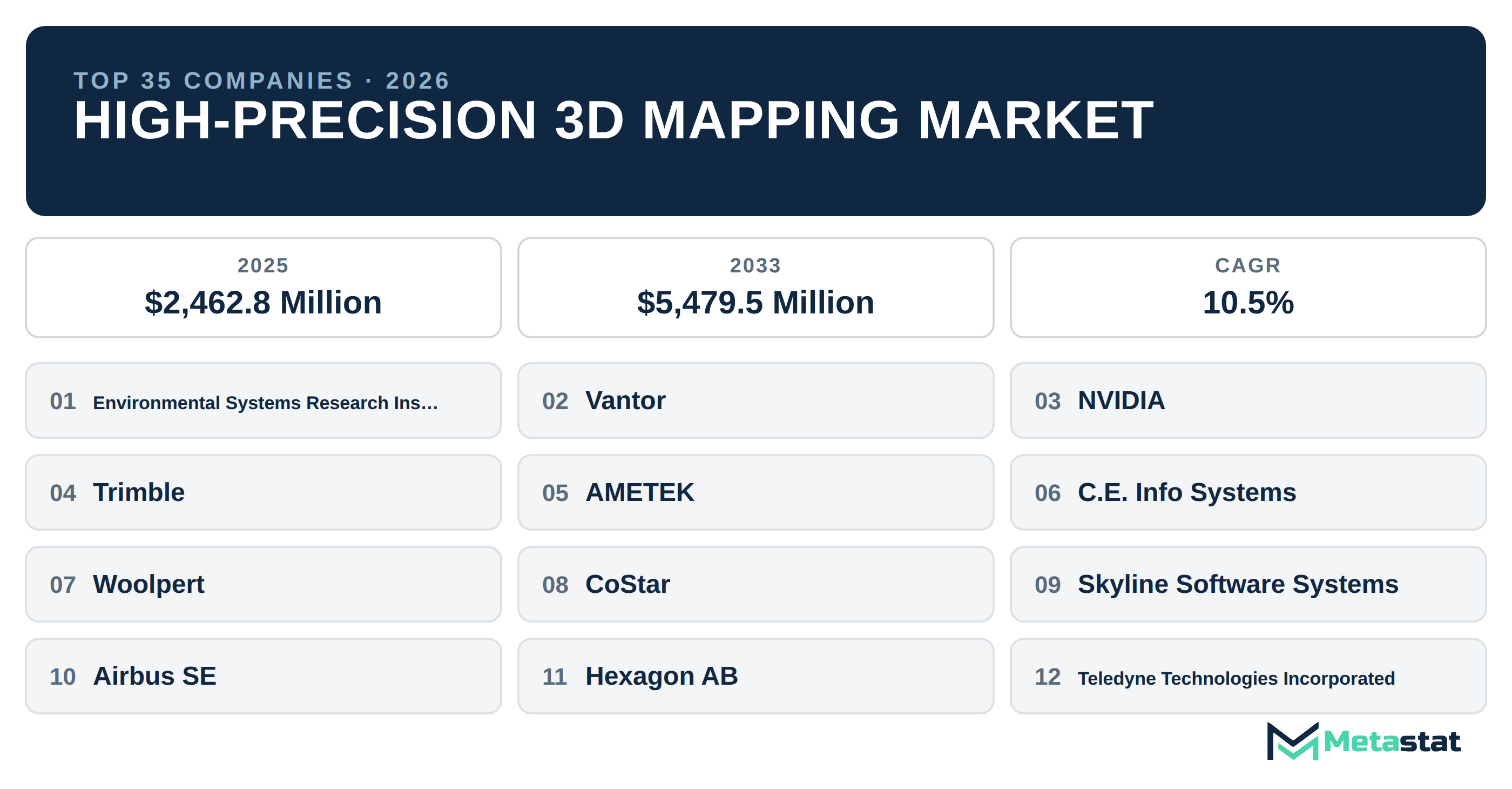
Explore the top 35 companies in the High-Precision 3D Mapping industry, showcasing their innovative solutions and contributions to diverse sectors.
The High-Precision 3D Mapping industry specializes in creating detailed digital representations of geographical areas using advanced technologies such as LiDAR and photogrammetry. Applications range from urban planning and infrastructure development to automotive navigation and environmental monitoring. Companies in this sector serve a diverse clientele, including government agencies, construction firms, and technology developers. Rapid technological advancements are transforming the industry, enhancing accuracy and accessibility. For in-depth insights, refer to our High-Precision 3D Mapping market size and forecast report.
Top 10 High-Precision 3D Mapping Trends
Inline metrology moves onto the production line
Inline metrology integrates measurement systems directly into production workflows, enabling real-time quality control. This trend reduces errors, lowers costs, and enhances product accuracy. Manufacturers adopting this technology streamline operations and improve overall efficiency.
AI enhances data analysis
Artificial intelligence plays a crucial role in analyzing vast datasets generated by 3D mapping technologies. AI algorithms identify patterns and insights that inform decision-making in urban planning, asset management, and environmental monitoring, leading to more informed strategies.
Cloud-based solutions gain traction
Cloud technologies facilitate real-time collaboration and data sharing across geographic boundaries. This trend allows businesses and teams to access 3D mapping data from anywhere, promoting efficiency in projects requiring input from multiple stakeholders.
Integration of augmented reality
Augmented reality (AR) applications are emerging within the 3D mapping sector, enabling users to visualize mapping data in immersive environments. This capability enhances design processes and stakeholder engagement, making it easier to communicate complex information.
Increased focus on sustainability
Environmental considerations lead to a rise in sustainable practices within the industry. Companies develop solutions designed to minimize ecological impact, leveraging 3D mapping for applications in conservation, resource management, and urban planning.
Mobile mapping technologies expand
Mobile mapping technologies gain popularity due to their ability to capture data on-the-go. This trend benefits sectors like transportation and logistics, where real-time information is crucial for planning and operational efficiency.
Consumer applications grow
High-Precision 3D Mapping increasingly finds applications in consumer-facing products, such as navigation systems and gaming. This shift expands the industry's reach, creating new opportunities for growth and innovation.
Collaboration with smart city initiatives
Partnerships between 3D mapping companies and smart city initiatives rise. Collaborative efforts focus on integrating mapping technologies into urban infrastructure, enhancing data collection and analysis for better city management.
Advanced sensor technology development
Developments in sensor technology push the boundaries of accuracy in 3D mapping. New sensors improve data collection methods, resulting in high-resolution maps serving diverse applications from construction to environmental monitoring.
Growing demand from the automotive sector
The automotive industry increasingly relies on 3D mapping for autonomous vehicle development and navigation systems. This trend drives innovation and investment in mapping technologies, shaping the future of transportation.
High-Precision 3D Mapping Companies Profiled
1. Environmental Systems Research Institute, Inc. (Esri)
Headquarters: Redlands, United States · Founded: 1969. Esri specializes in geographic information system (GIS) software and technology, enabling users to visualize, analyze, and interpret spatial data. Its ArcGIS platform is widely utilized for creating detailed maps and conducting spatial analysis across various industries, including government, urban planning, and environmental management.
2. Vantor
Vantor focuses on providing advanced 3D mapping solutions tailored to the needs of the construction and engineering sectors. The company emphasizes precision and usability, offering software tools that facilitate project planning, progress monitoring, and data analysis to enhance decision-making processes.
3. NVIDIA Corporation
NVIDIA develops powerful graphics processing units (GPUs) and software platforms that drive high-performance computing in 3D mapping applications. The company's solutions enhance rendering and processing capabilities for spatial data, enabling faster analysis and visualization in industries such as gaming, architecture, and autonomous driving.
4. Trimble Inc.
Trimble provides an array of solutions for a range of industries, including construction, agriculture, and transportation. Their 3D mapping technologies integrate GNSS (Global Navigation Satellite System) and other positioning technologies to improve project accuracy and efficiency. Trimble's focus on innovation supports the development of smart infrastructure and sustainable practices.
5. AMETEK, Inc.
AMETEK is known for its precision measurement and automation solutions, which include advanced 3D mapping technologies. The company serves various industries, leveraging its expertise to deliver high-quality data acquisition systems that support applications in manufacturing, aerospace, and energy management.
6. C.E. Info Systems Limited (MapmyIndia)
MapmyIndia specializes in digital mapping and location-based services in India. The company provides high-resolution mapping data and solutions for businesses, including logistics, automotive, and government. Their focus on local conditions enables precise geospatial analytics and navigation solutions tailored to the Indian market.
7. Woolpert, Inc.
Woolpert is a geospatial consulting firm that combines mapping, engineering, and technology services. The company offers a comprehensive range of solutions, from aerial mapping and surveying to GIS and data management, focusing on delivering accurate and actionable insights to clients in various sectors, including government and transportation.
8. CoStar Group, Inc.
CoStar Group provides commercial real estate information, analytics, and online marketplaces. Their 3D mapping solutions enhance property analysis and visualization, empowering clients in the real estate sector to make informed decisions based on accurate geographic data and market insights.
9. Skyline Software Systems, Inc.
Skyline Software Systems specializes in developing 3D visualization and mapping solutions for various industries. Their software platforms enable users to create detailed urban models and analyze geospatial data, focusing on applications in urban planning, architecture, and environmental assessment.
10. Airbus SE
Airbus is a global aerospace leader that incorporates High-Precision 3D Mapping technologies into various applications, including satellite imagery and remote sensing. Their solutions support defense, urban planning, and environmental monitoring, leveraging data to enhance decision-making in complex scenarios.
11. Hexagon AB
Hexagon offers integrated solutions for geospatial information and industrial automation. The company’s 3D mapping technologies serve industries such as construction, mining, and agriculture, providing tools that improve accuracy and efficiency in data collection and analysis.
12. Teledyne Technologies Incorporated
Teledyne Technologies delivers advanced imaging and sensors for various applications, including High-Precision 3D Mapping. Their technologies support industries such as aerospace, defense, and environmental monitoring, providing accurate data to drive informed decisions.
13. HERE Technologies
HERE Technologies specializes in mapping and location data, offering solutions for automotive, logistics, and smart city applications. Their platform provides robust geospatial data and analytics, enhancing navigation and location-based services for clients worldwide.
14. Dassault Systèmes SE
Dassault Systèmes provides software solutions for 3D design, 3D digital mock-up, and product lifecycle management. Their technologies support industries such as aerospace, automotive, and construction, enabling companies to visualize and simulate projects accurately.
15. PASCO Corporation
PASCO Corporation specializes in high-precision measurement and mapping solutions for the civil engineering and environmental sectors. Their products and services facilitate accurate data collection and analysis, helping clients in planning and monitoring projects.
16. The Sanborn Map Company, Inc.
The Sanborn Map Company has a long history in providing detailed mapping solutions, particularly for urban and infrastructure planning. Their products are essential for government agencies and commercial clients requiring precise geographic information.
17. Agisoft LLC
Agisoft develops software for photogrammetry and 3D modeling, offering solutions that cater to industries such as archaeology, film production, and surveying. Their tools create accurate 3D models from images, enhancing various applications that require spatial analysis.
18. TomTom N.V.
TomTom is known for its navigation and mapping products. The company provides high-resolution maps and location-based services, catering to automotive, telematics, and consumer markets. Their focus on innovation drives the development of smart navigation solutions.
19. Genesys International Corporation Limited
Genesys International specializes in geospatial solutions, offering services that include aerial mapping and GIS. Their technologies support sectors such as urban planning, infrastructure development, and environmental monitoring, providing clients with accurate and actionable data.
20. Surveying And Mapping, LLC (SAM)
SAM provides comprehensive surveying and mapping services, focusing on integrating advanced technology into their workflow. Their solutions cater to government and commercial clients, ensuring precision in land development and infrastructure projects.
21. NavInfo Co., Ltd.
NavInfo is a leading provider of digital mapping and location-based services in China. The company focuses on delivering high-quality geographic information and solutions for automotive navigation, urban planning, and smart city development.
22. Autodesk, Inc.
Autodesk develops software for architecture, engineering, construction, and manufacturing. Their solutions integrate High-Precision 3D Mapping technologies to enhance design processes, allowing users to create detailed visualizations and simulations of projects.
23. SimActive Inc.
SimActive specializes in software for photogrammetry and geospatial analysis. Their products enable users to process aerial imagery and create 3D models efficiently, serving industries such as surveying, mining, and environmental management.
24. Dynamic Map Platform Co., Ltd.
Dynamic Map Platform focuses on providing high-resolution mapping data, primarily for the automotive and mobility sectors. Their solutions support navigation and autonomous driving technologies, enhancing safety and precision in transportation.
25. Fugro N.V.
Fugro operates in geotechnical, survey, and geospatial services, leveraging High-Precision 3D Mapping technologies to gather data for various projects. Their focus on innovation and quality supports industries such as oil and gas, construction, and environmental management.
26. Ecopia Tech Corporation
Ecopia Tech creates high-definition 3D mapping solutions using AI and machine learning. The company provides accurate geospatial data for urban planning, transportation, and infrastructure management, helping clients make informed decisions based on reliable insights.
27. 3Dsurvey d.o.o.
3Dsurvey specializes in software solutions for surveying and mapping. Their tools enable users to create 3D models and perform geospatial analysis, focusing on industries such as construction, mining, and archaeology, improving data accuracy and usability.
28. Bentley Systems, Incorporated
Bentley Systems provides software solutions for infrastructure design, construction, and operations. Their 3D mapping technologies enhance project visualization and analysis, helping professionals in architecture, engineering, and construction optimize their workflows.
29. CyberCity 3D, Inc.
CyberCity 3D specializes in 3D city modeling and visualization solutions. Their products support urban planning and development projects, providing detailed models that assist stakeholders in understanding and managing urban environments.
30. NavVis GmbH
NavVis offers indoor mapping and navigation solutions using advanced 3D scanning technology. Their products enhance building management and facility planning, enabling clients to visualize and optimize indoor spaces effectively.
31. Pix4D SA
Pix4D is known for its photogrammetry software that creates 3D models and maps from images. The company's solutions are widely used in agriculture, construction, and surveying, providing accurate data for analysis and planning.
32. Terrasolid Oy
Terrasolid develops software for processing LiDAR data and creating 3D mapping solutions. Their tools are essential for surveying and civil engineering, enabling users to extract valuable insights from point cloud data.
33. Topcon Corporation
Topcon provides precision measurement and positioning solutions for construction, agriculture, and surveying. Their 3D mapping technologies integrate seamlessly into workflows, enhancing accuracy and efficiency across various applications.
34. Asia Air Survey Co., Ltd.
Asia Air Survey specializes in aerial surveying and mapping services, focusing on delivering high-quality geospatial data for urban planning and environmental monitoring. The company’s expertise supports various industries seeking precise geographic information.
35. Intermap Technologies Corporation
Intermap Technologies offers 3D mapping and geospatial data solutions, leveraging radar technology to create detailed topographic maps. Their services cater to diverse sectors, including insurance, aviation, and utilities, providing clients with accurate and reliable information for decision-making.
Conclusion
The High-Precision 3D Mapping industry experiences significant transformations driven by technological advancements and increasing applications across various sectors. Companies within this sector focus on enhancing data accuracy, integrating AI and cloud technologies, and developing sustainable solutions. This list of High-Precision 3D Mapping companies highlights the diverse approaches and innovations shaping the industry.
As the demand for precision mapping continues to grow, stakeholders should remain informed about the latest trends and technologies. The Global High-Precision 3D Mapping Market provides further insights into the evolving landscape, equipping businesses with the knowledge needed to thrive in this dynamic sector.
Tags
About the Authors

LEAD ANALYST
Utkarsh Khirodkar is a Lead Market Research Analyst at MetaStat Insight, specializing in market intelligence, technology sector assessments, and competitive strategy.

INDUSTRY CONSULTANT - CHEMICALS & ADVANCED MATERIALS
Chemicals and Materials · Machinery & Equipment · Packaging
Amit Gadhekar Consultant for Chemicals and Materials at MetaStat Insight, directing sector-specific intelligence, research, and strategic consulting across global chemical and processing markets.

PRINCIPAL CONSULTANT - QUALITY SYSTEMS & COMPLIANCE
Electronics and Semiconductor · Machinery & Equipment · Professional Services
Omkar Phadtare is an Industry Consultant at MetaStat Insight, specializing in quality systems, regulatory compliance, and standards benchmarking to drive data-driven market intelligence and strategic industry research.

ENERGY & INFRASTRUCTURE INDUSTRY CONSULTANT
Automotive and Transportation · Electronics and Semiconductor · Energy and Power · Machinery & Equipment
Saurabh Vasant Ganvir consults for Energy & Infrastructure Industry at MetaStat Insight, specializing in renewable energy, solar EPC, and electric vehicle (EV) infrastructure markets.

LEAD CONSULTANT - COMMUNICATION, TELECOM, AND IT
Electronics and Semiconductor · Information & Technology · Machinery & Equipment · Professional Services
Ravindra Sathe Consultants for Communication, Telecom, and IT at MetaStat Insight. He leads the firm's industry research initiatives across telecommunications infrastructure, digital connectivity, enterprise networking, and emerging information technology domains.