
LEAD ANALYST
Utkarsh Khirodkar is a Lead Market Research Analyst at MetaStat Insight, specializing in market intelligence, technology sector assessments, and competitive strategy.

Global High-Precision 3D Mapping Market Size, Share, By Offering (Mapping Software, 3D Map Data Licensing & Subscriptions, Mapping & Update Services), By Technology (LiDAR-Based Mapping, Photogrammetry-Based Mapping, Radar Interferometry-Based Mapping, Multi-Sensor Fusion Mapping), By Mapping Environment (Outdoor Mapping, Indoor Mapping, Integrated Indoor-Outdoor Mapping), By End-Use Industry (Automotive & Mobility, Architecture, Engineering & Construction, Government & Urban Planning, Energy & Utilities, Mining & Aggregates, Agriculture & Forestry, Defense & Security, Telecommunications), Industry Analysis, Growth, Trends, and Forecast, 2026-2033
Report ID
MSI-5623
Published
October, 2026
Pages
268 Pages
Format
Historical
Base year
Forecast
Forecast period
Report Details
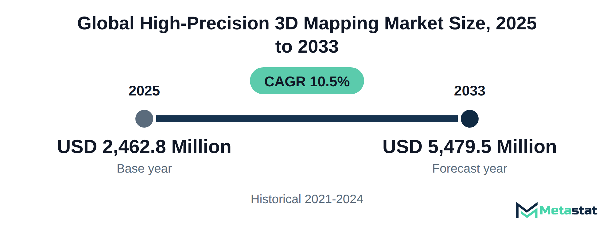
Market Valuation: Valued at $2,462.8 Million in 2025, projected to reach $5,479.5 Million by 2033 at a 10.5% CAGR.
Dominant Segment: The 3D Map Data Licensing & Subscriptions segment leads the market, driven by the increasing reliance on accurate mapping data for applications such as autonomous vehicle navigation and urban planning.
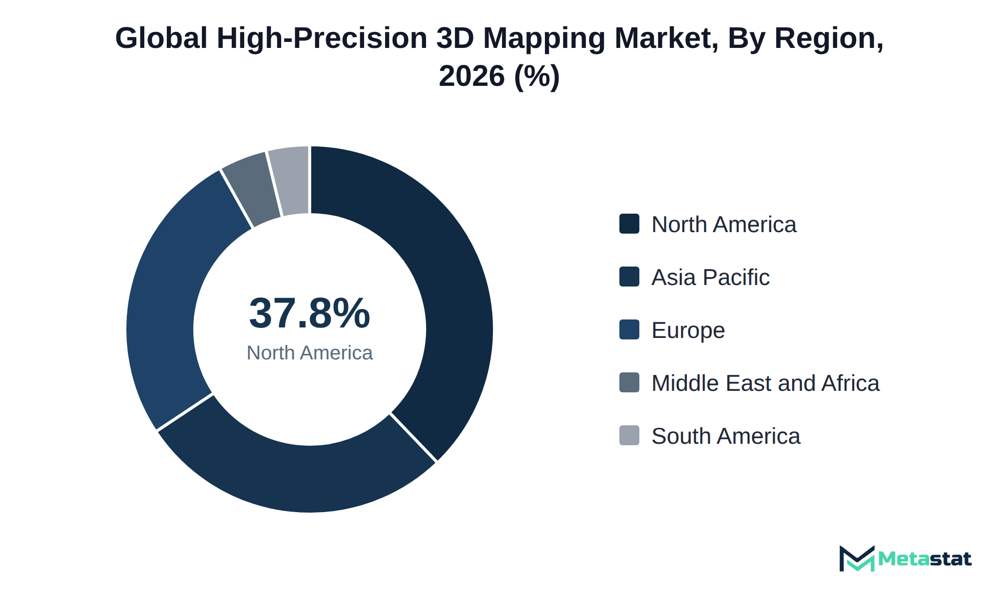
Geographic Lead: North America is the leading region, accounting for 37.8% of the market in 2025, with the US expected to maintain this dominance due to significant investments in high-precision mapping technologies.
What's Inside: This report provides a comprehensive analysis of the competitive landscape, market segmentation by offering, technology, mapping environment, and end-use industry, along with detailed forecasts through 2033.
Technological Advancements: The integration of LiDAR and photogrammetry technologies enhances the accuracy of mapping solutions, supporting growth across various sectors including automotive, construction, and urban planning.
Market Dynamics: Rising costs and margin pressures are significant challenges for suppliers, impacting the accessibility of high-precision mapping technologies for smaller enterprises.
Choose Your License
Global High-Precision 3D Mapping Market
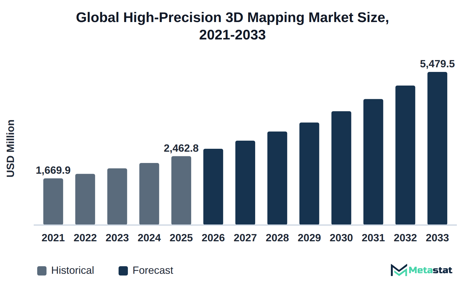
The global High-Precision 3D Mapping market was valued at USD 2,462.8 million in 2025 and is projected to reach USD 5,479.5 million by 2033, growing at a CAGR of 10.5% over the forecast period.
The High-Precision 3D Mapping market encompasses advanced technologies and methodologies for creating detailed three-dimensional representations of geographical areas. Buyers invest in these solutions to enhance operational efficiency, improve decision-making processes, and facilitate the development of innovative applications across diverse sectors. Key end-users come from industries such as automotive, engineering, construction, and urban planning, all of which rely on precise mapping for effective project execution and resource management.
Growth in the market is driven by increasing demand for real-time data and high-quality mapping solutions that support the development of autonomous systems, smart cities, and infrastructure projects. The segment with the highest value is 3D Map Data Licensing & Subscriptions, which reflects the growing reliance on accurate data for various applications. North America holds 37.8% of the market in 2025, with the US leading in 2026, highlighting the region's significant investment in high-precision mapping technologies.
Technological advancements in LiDAR, photogrammetry, and multi-sensor fusion mapping have further fueled market growth, enabling enhanced accuracy and efficiency in data collection. These innovations contribute to improved performance in both outdoor and indoor mapping environments, driving adoption across multiple industries. The market expands as organizations recognize the value of integrating high-precision mapping solutions into operations.
The High-Precision 3D Mapping market addresses a broad spectrum of applications ranging from urban planning to autonomous vehicle navigation. Buyers invest in this technology to enhance accuracy and efficiency in mapping tasks, facilitating improved decision-making processes across various sectors. This technology lets users gather, analyze, and visualize spatial data, which brings operational benefits.
Growth in the market primarily stems from the rising demand for high-quality mapping solutions in the automotive and mobility sectors. The automotive and mobility segment represents the largest share, reflecting a strong push towards the integration of advanced mapping technologies in self-driving vehicles and smart city initiatives. This regional dominance results from significant investments in digital infrastructure and increased adoption of 3D mapping technologies across various industries.
The market is projected to experience sustained growth driven by advancements in LiDAR and photogrammetry technologies, which enhance the precision and efficiency of mapping processes. Innovations in multi-sensor fusion mapping are expected to further support market expansion, enabling users to obtain more reliable and comprehensive data sets. Stakeholders see a significant opportunity in the increasing demand for high-precision mapping solutions.
LiDAR and photogrammetry fusion has emerged as a critical technology in the High-Precision 3D Mapping market, significantly enhancing the accuracy of road, terrain, and building maps. The fusion of these two technologies combines their strengths. LiDAR provides detailed elevation data, while photogrammetry captures high-resolution imagery. This combination results in comprehensive and precise mapping solutions that meet the rigorous demands of various industries.
By 2033, the LiDAR-based mapping segment is projected to reach USD 1,985.8 million, reflecting a compound annual growth rate (CAGR) of 9.3%. This growth highlights the increasing reliance on accurate mapping data for applications including autonomous vehicles, urban planning, and construction projects. Organizations seek to improve operational efficiency and decision-making capabilities, driving demand for high-quality mapping data.
Integrating LiDAR and photogrammetry improves map accuracy and speeds up the mapping process, which shortens project turnaround times. This efficiency provides a competitive advantage for businesses in sectors including automotive, architecture, engineering, and construction. Companies aiming to enhance their service offerings and stay relevant in the High-Precision 3D Mapping market need to invest in these technologies.
Recurring map updates and data licensing represent critical components within the High-Precision 3D Mapping market, particularly for automotive and infrastructure workflows. The pricing models for these services frequently employ subscription-based contracts, allowing users to access updated mapping data continuously. This approach benefits clients by lowering upfront costs while securing ongoing access to the latest data vital for operational efficiency.
For instance, the segment of 3D Map Data Licensing & Subscriptions is projected to reach USD 2,096.4 million by 2033, reflecting a compound annual growth rate (CAGR) of 11.1%. This growth highlights the increasing reliance on real-time data, which is essential for sectors including automotive navigation and urban planning. Companies investing in such services recognize that integrating up-to-date mapping data into their systems directly enhances decision-making processes and operational workflows.
The competitive landscape for data providers emphasizes flexibility in contract terms and pricing strategies, with businesses seeking tailored solutions that fit their specific needs. Long-term agreements often yield reduced rates, incentivizing companies to lock in pricing against market fluctuations. Consequently, this dynamic enables greater investments in mapping technologies, reinforcing the significance of recurring updates and data licensing in driving growth within the market.
High-Precision 3D Mapping technology plays a key role in developing accurate and interoperable 3D digital twins. Enhanced positional accuracy remains critical for industries including Automotive & Mobility, where precise mapping influences navigation and safety systems. The segment is projected to grow from USD 796.7 million in 2026 to USD 1,744.7 million by 2033, reflecting a compound annual growth rate of 11.8%. This growth reflects rising demand for advanced surveying techniques that ensure reliability in mapping outputs.
Survey control practices significantly improve the quality of 3D digital twins, enabling effective integration across various platforms and applications. By leveraging technologies including LiDAR and photogrammetry, organizations in construction, urban planning, and smart city initiatives enhance operational efficiency and decision-making accuracy. The integration of these technologies encourages collaboration among stakeholders, ensuring effective data sharing and operational workflows. While the market evolves, the emphasis on interoperability becomes increasingly important for companies aiming to maintain competitive advantage.
Investment in high-precision mapping tools enhances the capability of organizations to deliver detailed digital representations of physical environments. The resulting digital twins serve diverse applications, from infrastructure management to environmental monitoring. With increasing reliance on precise data, organizations prioritize systems that maximize survey control and positional accuracy within the High-Precision 3D Mapping market.
Ensuring accuracy in high-precision 3D mapping is essential for buyers to achieve reliable outcomes in their projects. One critical validation method is adopting mapping software, which is projected to reach USD 1,831.8 million by 2033, reflecting a compound annual growth rate (CAGR) of 11.3% from 2026. This growth illustrates the increasing demand for advanced tools that enhance accuracy in mapping processes.
Buyers often seek to employ LiDAR-based mapping technology, which is expected to grow from USD 1,064 million in 2026 to USD 1,985.8 million by 2033, resulting in a CAGR of 9.3%. Such technology provides high-resolution data critical for applications in various industries, including automotive and construction. By integrating these advanced technologies, buyers ensure the accuracy of their mapping projects, leading to improved operational efficiencies and lower costs.
Investing in high-precision 3D mapping solutions leads to better data quality and enhances decision-making capabilities across projects. Buyers who validate accuracy through these methods position themselves strategically within the market, facilitating stronger project outcomes and competitive advantages.
The automotive and mobility sectors increasingly invest in high-precision mapping technologies driven by rising demand for advanced navigation systems and autonomous vehicle applications. This shift reflects a broader trend toward enhanced safety, efficiency, and user experience in transportation. Manufacturers prioritize integration of real-time mapping data into their vehicles, and sales volume rises significantly, contributing to overall market growth. The mapping software segment grows from USD 867.9 million in 2026 to USD 1,831.8 million by 2033, exemplifying this trend. The strengthening focus on vehicle automation drives demand for precise mapping solutions, ultimately influencing investment and competitive dynamics across the market.
In addition to automotive, industries including architecture and construction recognize the value of high-precision mapping, further expanding the market. Growth in these sectors supports increased spending on mapping technologies, leading to a favorable environment for innovation and development. Integration across various applications shows how high-precision mapping is shaping the future of mobility and infrastructure.
Integration of multi-sensor technologies drives significant advancements in the High-Precision 3D Mapping market. The capability to combine data from various sensor types, including LiDAR, photogrammetry, and radar interferometry, enhances the accuracy and reliability of 3D mapping outputs. This technological evolution stems from the growing demand for comprehensive mapping solutions across numerous industries, including automotive, construction, and urban planning.
Key benefits of multi-sensor integration include improved data richness and enhanced spatial resolution, which support applications requiring detailed environmental understanding. The market sees increasing adoption of such integrated systems by industries aiming to optimize workflows and improve operational efficiencies. Enhanced data accuracy translates into better decision-making processes, driving growth in sectors that rely heavily on precise geographical representations.
Investments in multi-sensor solutions reflect a strategic response to evolving project requirements and heightened expectations for data fidelity. This trend positions companies favorably within the competitive landscape, promoting innovation and further advancements in mapping technologies.
High-Precision 3D Mapping technologies face constraints due to increasing costs associated with software licensing and hardware procurement. These expenses particularly affect several small to medium-sized enterprises in the architecture, engineering, and construction sectors, where budget limitations hinder the ability to invest in advanced mapping solutions. Consequently, slower adoption rates arise, resulting in smaller order volumes and delayed project timelines. This situation impacts overall market growth, with firms struggling to integrate high-precision mapping into their workflows effectively. The market continues to evolve, yet ongoing cost challenges restrict broader implementation across diverse industries, limiting the technology's impact on operations and efficiency.
Rising operational expenses create significant margin pressure for suppliers in the High-Precision 3D Mapping market. Increasing costs associated with high-end technology deployment, including sophisticated software and advanced hardware, erode profit margins. Suppliers face challenges in maintaining competitive pricing while investing in necessary technological advancements to meet customer demands. This situation prompts organizations to explore strategic partnerships and invest in research and development to enhance efficiency. Suppliers focus on optimizing their service delivery models to mitigate costs while ensuring high-quality outputs. Several businesses are transitioning to subscription-based models for software offerings, allowing for more predictable revenue streams while aligning operational costs with customer usage. This shift represents a response to financial pressures experienced across the market, creating a more sustainable growth trajectory despite prevailing challenges.
LiDAR-based mapping represents a significant growth opportunity within the High-Precision 3D Mapping market. Industries including automotive and government infrastructure are the primary adopters, driven by increasing requirements for detailed environmental data and enhanced spatial analysis capabilities. The growing emphasis on smart city initiatives and autonomous vehicle technologies accelerates the demand for precise mapping solutions. Addressing these needs aligns with technological advancements, enabling providers to improve product offerings and capture a larger market share. The evolution of LiDAR technology positions it as a vital component in meeting the operational and strategic demands of various sectors, supporting sustained growth in the market.
The Global High-Precision 3D Mapping market is segmented based on Offering, Technology, Mapping Environment, and End-Use Industry.
This segment serves various industries, including automotive, construction, and urban planning, enabling precise mapping and analysis of geographical areas. Driving factors for this segment include increasing demand for advanced navigation systems and growing emphasis on accurate data for infrastructure projects. Compared to other segments, Mapping Software exhibits a higher growth rate due to its expanding role in digital transformation and integration of smart technologies. Continuous evolution of software solutions enhances user experience and operational efficiency, positioning this segment for significant growth. Increased reliance on digital mapping solutions across multiple sectors contributes significantly to its rising market value.
This segment serves various industries including automotive, urban planning, and construction, facilitating access to up-to-date geographic information crucial for decision-making and project planning. Demand growth in this segment is driven by the increasing reliance on accurate mapping data for autonomous vehicle navigation and infrastructure development. Unlike other segments including Mapping Software, which grows at a slightly higher CAGR of 11.3%, this segment provides essential data for applications requiring continuous updates and licensing agreements. It caters to a specific buyer group that prioritizes accurate and timely data. The increasing adoption of subscription models further enhances the segment's attractiveness, ensuring sustainable revenue streams for service providers.
Mapping & Update Services segment is expected to reach USD 1,551.2 million by 2033. This segment delivers timely updates and accurate mapping data to industries including automotive, urban planning, and construction. Key drivers of this segment include growing demand for real-time data for navigation and infrastructure development. This segment exhibits a compound annual growth rate (CAGR) of 11.1%, which positions it slower than the Mapping Software segment, expected to grow at a CAGR of 11.3%. The need for regular updates and reliable data licensing differentiates it from other offerings, where one-time purchases are more common. Organizations recognize the importance of maintaining up-to-date information, significantly influencing operational efficiency. With a focus on continuous improvement, the segment aligns closely with dynamic industry demands.
This technology primarily serves industries including automotive, construction, and land surveying for creating high-resolution maps and 3D models of landscapes and structures. Demand for precision mapping in autonomous vehicles and urban planning significantly drives growth in this segment. Compared to other technological approaches, LiDAR offers advantages in data accuracy and detail, although it typically incurs higher costs. Radar interferometry-based mapping and photogrammetry-based mapping exhibit growth rates at CAGRs of 9.4% and 9.3%, respectively, while the LiDAR segment shows a competitive edge due to its advanced capabilities in outdoor mapping applications. This differentiation positions LiDAR-based mapping as a vital component of the evolving market.
Photogrammetry-Based Mapping segment is estimated to reach USD 1,470.1 million by 2033, at a CAGR of 9.4% during the forecast period. This technology employs photographs taken from various angles to generate precise 3D models of environments. Common applications include topographic mapping, urban planning, and infrastructure development, serving industries including architecture, engineering, and construction. The increasing demand for high-quality visual data drives adoption in this segment. Compared to LiDAR-based mapping, which is projected to grow at a CAGR of 9.3%, photogrammetry offers a more cost-effective solution, appealing to budget-conscious clients. The segment's growth is supported by advancements in camera technology and software algorithms that enhance image processing capabilities, allowing for more accurate and detailed mapping outputs.
Radar interferometry-based mapping is expected to reach USD 524.4 million by 2033. This technology applies radar signals to generate high-precision topographical information, which finds applications in sectors including environmental monitoring, urban planning, and disaster management. The primary demand driver stems from the increasing need for accurate and timely data in various government and commercial projects. This segment differentiates itself from others, including LiDAR-based mapping, which is anticipated to grow at a CAGR of 9.3%. Radar interferometry-based mapping serves specialized needs with a unique ability to operate in adverse weather conditions, making it particularly beneficial for applications requiring constant data accuracy without interruptions. This capability supports steady demand among users focused on critical infrastructure and safety assessments.
Multi-Sensor Fusion Mapping segment is projected to grow at a CAGR of 15.4% during the forecast period. This technology integrates data from multiple sources, enhancing the accuracy and detail of 3D maps. Industries including automotive, urban planning, and construction adopt this approach to streamline operations and improve decision-making. Demand for this segment arises primarily from the growing emphasis on real-time data and the need for comprehensive mapping solutions. In contrast to other technology segments, Multi-Sensor Fusion Mapping exhibits a higher growth rate, driven by its potential to deliver superior accuracy and adaptability. This positions the segment favorably within the High-Precision 3D Mapping market, attracting significant investment and interest from key players seeking advanced mapping capabilities.
Depth-camera reconstruction and structured-light scanning employ advanced imaging techniques to capture three-dimensional data of objects and environments. These technologies find use in various fields, including architecture, virtual reality, and robotics, where high-precision imaging is essential. Factors driving demand for this segment include the rising adoption of augmented reality applications and the increasing need for accurate object scanning in design processes. This sub-segment differs from others by focusing on specific applications that require fine-detail imaging rather than broader mapping solutions. Consequently, customers in this segment include technology developers and design firms rather than traditional mapping agencies. This specialization influences purchasing patterns and pricing strategies, differentiating it from segments like LiDAR and photogrammetry-based mapping, which serve more generalized market needs. The High-Precision 3D Mapping market benefits from these diverse technological advancements.
The Outdoor Mapping segment is valued at USD 1,943.6 million in 2026 and is projected to reach USD 3,631.2 million by 2033, at a CAGR of 9.3% during the forecast period. This segment serves various industries, including construction, agriculture, and urban planning, where detailed mapping of outdoor environments is essential for operational efficiency. A critical driver for this segment is the increasing demand for accurate terrain visualization and analysis, particularly in sectors relying on precise geographic data for project planning and execution. Compared to Indoor Mapping, Outdoor Mapping experiences a higher growth rate, supported by advancements in technologies including LiDAR and photogrammetry, which enhance data collection and processing speed. The integration of outdoor mapping capabilities into various applications provides a competitive edge in the High-Precision 3D Mapping market.
Indoor Mapping is estimated to reach USD 1,225.2 million by 2033, at a CAGR of 11.7% during the forecast period. This segment finds extensive application in facilities management, retail analytics, and indoor navigation systems employed by various industries including healthcare and education. Growing demand for accurate indoor positioning systems drives this segment, with businesses seeking to enhance user experience and operational efficiency. Compared to other mapping environments, Indoor Mapping exhibits a strong growth trajectory due to rising investments in smart building technologies and the proliferation of mobile applications requiring precise navigation. The significant increase in demand for integrated indoor-outdoor mapping solutions further differentiates this segment, highlighting its unique value proposition within the market.
Integrated Indoor-Outdoor Mapping segment is expected to reach USD 623 million by 2033. This segment provides valuable solutions for users requiring effective navigation and mapping experiences across both indoor and outdoor environments. Industries including architecture, urban planning, and logistics leverage this technology to enhance operational efficiency and improve user experience. The segment experiences growth driven by increasing demand for integrated solutions that facilitate comprehensive mapping capabilities. Compared to other segments, integrated mapping exhibits a different growth trajectory, with a higher focus on indoor applications, reflected in its anticipated CAGR of 11.7%. Growth in this area results from technological advancements that enable accurate data capture and analysis across varying environments, further supporting its integration into various sectors. The High-Precision 3D Mapping market benefits from these innovations, positioning this segment as a key contributor to overall market expansion.
This segment plays a critical role in enabling advanced navigation systems, particularly for autonomous vehicles and smart transportation solutions. Increased consumer demand for precise mapping solutions drives the need for accurate real-time data and integration with vehicle systems. Compared to other segments within the market, this segment exhibits a faster growth trajectory, influenced by technological advancements and regulatory support for automated driving technologies. The focus on safety and efficiency in transportation fuels investment in high-precision mapping technologies, reinforcing the segment's importance in shaping future mobility solutions.
Architecture, Engineering & Construction segment is estimated to reach USD 1,171 million by 2033, at a CAGR of 9.9% during the forecast period. This segment serves various stakeholders, including architects, engineers, and construction companies, facilitating design and planning processes through accurate and detailed mapping solutions. The increasing demand for sustainable infrastructure development and efficient project management drives growth in this segment. Adoption of advanced technologies, including 3D mapping, enhances visualization and collaboration among stakeholders, resulting in improved project outcomes. Compared to other segments, the Architecture, Engineering & Construction segment exhibits moderate growth, influenced by regulatory requirements and the need for greater precision in construction projects. In contrast, segments like Automotive & Mobility experience faster growth rates, reflecting differing market dynamics and buyer requirements.
The Government & Urban Planning segment is expected to reach USD 694.8 million by 2033. This segment encompasses the use of high-precision mapping technologies by governmental bodies and urban planners for effective land use, infrastructure development, and resource management. Adoption is driven by the increasing demand for accurate data to support urban planning initiatives and the growing need for sustainable development practices. Compared to other segments, this segment exhibits a moderate growth rate, with a unique focus on regulatory compliance and public safety. The Government & Urban Planning segment responds to specific demands for detailed geographical data, which makes it distinct from the more commercially driven Automotive & Mobility segment. The Automotive & Mobility segment has a higher projected growth rate of 11.8% during the forecast period.
The Energy & Utilities segment is projected to grow at a CAGR of 11.3% during the forecast period. This segment serves utility companies and energy providers for applications including asset management, infrastructure monitoring, and environmental assessments. Increasing investments in renewable energy and smart grid technologies drive adoption, enhancing operational efficiencies and reducing costs. Regulatory pressures for sustainable practices influence demand. Compared to other segments, Energy & Utilities experiences significant growth due to the urgency of infrastructure upgrades and technological advancements. While Architecture, Engineering & Construction displays a CAGR of 9.9%, the Energy & Utilities segment exhibits a higher rate, positioning it for accelerated growth through 2033.
Mining & Aggregates involves the extraction and processing of natural resources, employing high-precision 3D mapping for topographical analysis, site planning, and monitoring of geological features. This segment serves mining companies and aggregate producers in optimizing operations, enhancing safety measures, and increasing efficiency in resource extraction. Demand for this segment stems from the growing focus on sustainable mining practices and regulatory compliance. Environmental regulations drive the adoption of advanced mapping technologies, enabling companies to minimize their ecological footprint while adhering to safety standards. Compared to other segments, Mining & Aggregates benefits from specific technologies tailored for rugged terrains and complex environments, ensuring accurate data collection and analysis. This distinct requirement positions the segment differently within the market, with potential for steady growth driven by ongoing industrial needs and technological advancements in 3D mapping solutions.
Agriculture & Forestry focuses on high-precision mapping technologies for effective land management, crop monitoring, and resource optimization. Stakeholders in this segment include farmers, land surveyors, and agricultural planners seeking to enhance yield and sustainability. Demand drivers include increasing agricultural productivity and the adoption of precision farming techniques, which aim to optimize inputs and maximize outputs. Compared to other segments, Agriculture & Forestry experiences slower growth due to factors including varying access to technology and differing levels of investment in precision agriculture across regions. Advanced mapping solutions tailored to the unique challenges of agricultural environments support better decision-making in modern farming practices.
Defense & Security focuses on the application of high-precision 3D mapping technologies for military and surveillance purposes. This segment serves defense agencies, military operations, and security firms that require accurate mapping for strategic planning and operational efficiency. Increasing attention on national security and the modernization of defense infrastructure drives demand. Advancements in mapping technologies enhance data accuracy and reliability, contributing to the segment's growth. This segment often commands higher prices compared to others due to the specialized requirements and critical nature of its applications. Competitive positioning emphasizes advanced technology and real-time data integration, differentiating it from broader applications in sectors including Automotive & Mobility and Architecture, Engineering & Construction. The market demonstrates a unique trajectory influenced by geopolitical factors, necessitating rapid adoption of innovative solutions to ensure operational effectiveness and situational awareness.
Telecommunications relies on high-precision 3D mapping technologies to enhance network planning, design, and maintenance. Telecommunications companies apply mapping data to optimize the deployment of communication infrastructure, improve service quality, and ensure efficient resource allocation. Growing demand for advanced connectivity solutions drives the segment, particularly due to increased 5G network and tower deployment. The industry faces challenges related to high costs associated with comprehensive mapping processes and data acquisition. Compared to other segments including Automotive & Mobility, which shows a stronger growth trajectory, Telecommunications experiences steadier growth with a focus on infrastructure reliability. The need for precise mapping in urban areas further distinguishes it from other applications, emphasizing the role of high-precision 3D mapping technologies in environmental adaptation and urban planning. Investment in this segment supports the broader aspirations of the market to enhance communication technologies.
This sub-segment encompasses applications in insurance, facility management, and cultural heritage. Utilization spans from capturing precise data for risk assessment in insurance to preserving historical sites through detailed documentation. The growing emphasis on asset management drives demand, with organizations seeking efficient solutions for monitoring and maintaining property conditions. Advances in technology, particularly in mapping accuracy and data integration, are expanding the segment's capabilities. Unlike more mainstream sectors including automotive and mobility, this segment experiences slower growth due to specific regulatory and funding constraints. Buyers in this sub-segment prioritize quality over cost, differentiating it from more price-sensitive areas of the market.
Based on geography, the Global High-Precision 3D Mapping market is divided into North America, Europe, Asia-Pacific, South America, Middle East, and Africa.
North America holds a significant position in the High-Precision 3D Mapping market, with a projected value of USD 1,908.5 million by the end of 2033. The region benefits from advanced infrastructure and a robust technology ecosystem, driving demand primarily from the automotive and mobility sector. Significant investments in smart city initiatives and urban planning enhance the adoption of high-precision mapping solutions across municipalities. The United States, Canada, and Mexico lead the way in applying these technologies for applications ranging from transportation planning to environmental monitoring. By 2025, North America is expected to account for USD 1,004.1 million of the global market, reflecting its strong influence in shaping the overall market growth.
Europe is a key player in the High-Precision 3D Mapping market, driven by strong demand from industries including architecture, engineering and construction, and government and urban planning. Countries like Germany, France, and the UK lead in adopting advanced mapping technologies, influenced by stringent regulations and a focus on urban development. The market share in Europe reflects ongoing investments in infrastructure and technological advancements. The integration of high-precision mapping solutions in various sectors supports enhanced decision-making and project efficiency, ensuring that stakeholders benefit from accurate data. While the market evolves, the emphasis on sustainability and smart city initiatives drives growth and innovation within the region.
Asia-Pacific holds a 27.8% share of the High-Precision 3D Mapping market in 2025. The demand in this region primarily stems from industries including automotive and construction, where precision mapping plays an essential role in enhancing design and operational efficiency. Countries including China and India invest heavily in infrastructure development, triggering an increased need for accurate mapping solutions. The rapid growth of smart city initiatives across Southeast Asia drives further adoption of high-precision mapping technologies. With advancements in LiDAR and photogrammetry, the market expands, addressing the specific requirements of various sectors within this diverse region.
Demand for high-precision 3D mapping in South America primarily stems from sectors including automotive and urban planning. Brazil and Argentina exhibit significant interest in mapping technologies to enhance urban infrastructure and improve transportation systems. The region's share of the global market is notable in 2025. Infrastructure development initiatives drive investment in mapping solutions, particularly in urban areas facing rapid growth. The need for accurate mapping data supports the advancement of smart city projects, encouraging collaboration among government agencies and private enterprises. These factors contribute to a strong market outlook while local industries seek to use high-precision mapping for operational efficiency and strategic planning.
The High-Precision 3D Mapping market in the Middle East and Africa experiences growth driven by advancements in various industries, particularly in Saudi Arabia and the UAE. Government initiatives focused on urban development and infrastructure projects enhance demand for high-precision 3D mapping solutions. South Africa's mining and construction sectors increasingly adopt these technologies to improve operational efficiency and project accuracy. The regulatory environment encourages investments in smart city initiatives, establishing a foundation for sustained market expansion. The region holds a 4.3% share of the global market in 2025. Its growth benefits from rising adoption across multiple sectors, including government, energy, and urban planning.
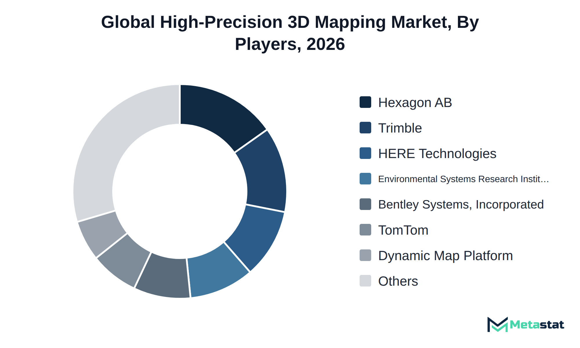
Competition in the High-Precision 3D Mapping market revolves around various strategies and service offerings. Key players including Hexagon AB, Trimble Inc., and Bentley Systems, Incorporated focus on diverse aspects of mapping technology, including software solutions, data licensing, and update services that cater to different customer needs.
Buyers prioritize factors including price, certification, customization, and service level when selecting a provider. For example, Environmental Systems Research Institute, Inc. (Esri) excels in providing mapping software tailored for user-specific applications, while Technologies emphasizes data accuracy and reliability. TomTom N.V. leverages its expertise in geolocation to offer integrated mapping solutions that enhance user experience.
Companies differentiate themselves through technology and service models. NavVis GmbH and Pix4D SA focus on technologies including photogrammetry and LiDAR-based mapping, catering to industries requiring high precision and detailed mapping solutions. Agisoft LLC and Autodesk, Inc. serve the architecture and construction sectors, providing tools that facilitate design and planning processes.
Firms like Teledyne Technologies Incorporated and Topcon Corporation emphasize their capabilities in multi-sensor fusion mapping, appealing to sectors that demand comprehensive and integrated mapping solutions. This strategic diversity within the market shapes the competitive environment and influences growth trajectories, driving innovation and investment across the sector.
This growth relies on several key developments in the High-Precision 3D Mapping market. Firstly, the expansion of the automotive and mobility segment, projected to grow at a CAGR of 11.8%, will drive demand for advanced mapping solutions, enabling improvements in navigation and autonomous vehicle technologies. Secondly, increasing investments in outdoor mapping technologies, particularly LiDAR-based mapping, projected to reach USD 1,985.8 million by 2033, will enhance data accuracy and detail in various applications. Lastly, the growth of mapping software offerings, expected to rise to USD 1,831.8 million, will cater to diverse industries needing precise spatial information.
However, significant risks exist that could hinder this growth. Economic downturns or shifts in regulatory frameworks impact funding and investment in high-precision technologies, particularly in North America and Europe, where many initiatives and advancements are concentrated. Maintaining momentum in innovation and adoption will be crucial for the market to achieve its projected size by 2033.
By Offering: Mapping Software, 3D Map Data Licensing & Subscriptions, Mapping & Update Services
By Technology: LiDAR-Based Mapping, Photogrammetry-Based Mapping, Radar Interferometry-Based Mapping, Multi-Sensor Fusion Mapping, Others (Depth-Camera Reconstruction, Structured-Light Scanning)
By End-Use Industry: Automotive & Mobility, Architecture, Engineering & Construction, Government & Urban Planning, Energy & Utilities, Mining & Aggregates, Agriculture & Forestry, Defense & Security, Telecommunications, Others (Insurance, Facility Management, Cultural Heritage)
The report strategically identifies and profiles the key market players and analyses their core competencies in each sub-segment of the High-Precision 3D Mapping market.
Report Attributes | Details |
Study Period | 2021-2033 |
Base Year | 2025 |
Estimated Year | 2026 |
Forecast Period | 2026-2033 |
Historical Period | 2021-2025 |
Growth Rate | CAGR 10.5% from 2026 to 2033 |
Revenue Unit | USD million |
Segmentation | By Offering, Technology, Mapping Environment, End-Use Industry, and Region |
By Region | North America (By Offering, Technology, Mapping Environment, End-Use Industry, and Country)
|
Europe (By Offering, Technology, Mapping Environment, End-Use Industry, and Country)
| |
Asia Pacific (By Offering, Technology, Mapping Environment, End-Use Industry, and Country)
| |
South America (By Offering, Technology, Mapping Environment, End-Use Industry, and Country)
| |
Middle East and Africa (By Offering, Technology, Mapping Environment, End-Use Industry, and Country)
|
Find answers to common questions about this report
The High-Precision 3D Mapping market size was valued at USD 2,462.8 million in 2025.
The market is projected to grow at a CAGR of 10.5% during the forecast period from 2026 to 2033.
The North America High-Precision 3D Mapping market size is estimated to reach USD 1,908.5 million by 2033.
The leading segment in the High-Precision 3D Mapping market is 3D Map Data Licensing & Subscriptions, with a projected value of USD 2,096.4 million by 2033. This segment surpasses others in terms of revenue potential.
The automotive and mobility sectors increasingly invest in high-precision mapping technologies due to rising demand for advanced navigation systems and autonomous vehicle applications. LiDAR-based mapping represents a significant growth opportunity, driven by increasing requirements for detailed environmental data and enhanced spatial analysis capabilities.
North America holds the dominant share of the High-Precision 3D Mapping market, with a value of USD 1,908.5 million projected for 2033. This region accounts for 37.8 percent of the total market share.
Increasing costs associated with software licensing and hardware procurement restrain growth in the High-Precision 3D Mapping market. This situation particularly affects small to medium-sized enterprises in architecture, engineering, and construction, resulting in slower adoption rates and smaller order volumes.
Rising demand for advanced navigation systems and autonomous vehicle applications drives adoption in the high-precision mapping industry. the integration of multi-sensor technologies enhances data accuracy and operational efficiency, further supporting market growth.
The High-Precision 3D Mapping market is estimated to reach a valuation of USD 5,479.5 million by 2033.
Key players operating in the High-Precision 3D Mapping market include Hexagon AB, Trimble Inc., Bentley Systems, Incorporated, Environmental Systems Research Institute, Inc. (Esri), Technologies, TomTom N.V., and NavVis GmbH.
The analysts below cover Machinery & Equipment research at Metastat Insights.
LEAD ANALYST
Utkarsh Khirodkar is a Lead Market Research Analyst at MetaStat Insight, specializing in market intelligence, technology sector assessments, and competitive strategy.

INDUSTRY CONSULTANT - CHEMICALS & ADVANCED MATERIALS
Chemicals and Materials · Machinery & Equipment · Packaging
Amit Gadhekar Consultant for Chemicals and Materials at MetaStat Insight, directing sector-specific intelligence, research, and strategic consulting across global chemical and processing markets.

PRINCIPAL CONSULTANT - QUALITY SYSTEMS & COMPLIANCE
Electronics and Semiconductor · Machinery & Equipment · Professional Services
Omkar Phadtare is an Industry Consultant at MetaStat Insight, specializing in quality systems, regulatory compliance, and standards benchmarking to drive data-driven market intelligence and strategic industry research.

ENERGY & INFRASTRUCTURE INDUSTRY CONSULTANT
Automotive and Transportation · Electronics and Semiconductor · Energy and Power · Machinery & Equipment
Saurabh Vasant Ganvir consults for Energy & Infrastructure Industry at MetaStat Insight, specializing in renewable energy, solar EPC, and electric vehicle (EV) infrastructure markets.

LEAD CONSULTANT - COMMUNICATION, TELECOM, AND IT
Electronics and Semiconductor · Information & Technology · Machinery & Equipment · Professional Services
Ravindra Sathe Consultants for Communication, Telecom, and IT at MetaStat Insight. He leads the firm's industry research initiatives across telecommunications infrastructure, digital connectivity, enterprise networking, and emerging information technology domains.
Our team was tracking whether regional recycling infrastructure could realistically absorb the growing volume of lithium iron phosphate batteries over the next decade. The report did a solid job separating announced hydrometallurgical plant capacity from active, permitted operational throughput. That distinction made the feedstock availability projections and regional recovery rate models far more credible than standard commercial overviews.
Tracking capacity expansion in single-use bioprocessing requires dependable data on raw material availability and cleanroom-grade polymer supply chains. The competitive landscape chapter gave a grounded evaluation of secondary component suppliers across North America and Asia-Pacific rather than simply reprinting press releases. Having that level of supplier benchmarking helped clarify dual-sourcing considerations for our clinical pipeline planning.
When evaluating distributed energy resource management systems, standard research summaries tend to gloss over the operational differences between front-of-the-meter utility deployments and behind-the-meter industrial sites. The MetaStat Insight report addressed those distinctions directly, especially regarding software interoperability standards and grid interconnection backlogs. The five-year market sizing across regional transmission organizations provided actionable context for our grid modernization strategy.
Explore related market intelligence reports worth reading alongside this one.