
LEAD ANALYST
Utkarsh Khirodkar is a Lead Market Research Analyst at MetaStat Insight, specializing in market intelligence, technology sector assessments, and competitive strategy.

Global 3D Mapping and Modeling Market Size, Share, By Component (Hardware, Software, and Services), By Type (3D Mapping and 3D Modelling), By Application (Projection Mapping, Texture Mapping, Maps and Navigation, 3D Rendering, and Visualisation), By End-users (Entertainment, Media, Healthcare, Building, Construction, Automotive, Transportation, Defense, and Security), Industry Analysis, Growth, Trends, and Forecast, 2026-2033
Report ID
MSI-4732
Published
May, 2026
Pages
315 Pages
Format
Report Details
Choose Your License
3D Mapping and Modeling Market
Global 3D Mapping and Modeling market size is valued at USD 8.7 billion in 2025 and projected to grow at a CAGR of 13.6% during the forecast period, reaching USD 24.2 billion by 2033.
North America holds 31.7% in 2025 with US leading the market share in 2025.
The hardware segment accounted for 36.4% of the market share in 2025.
Key trends driving growth: Increased adoption of geospatial intelligence and digital twin technologies across infrastructure and smart city projects, along with growing use of 3D visualization in construction, engineering, and autonomous navigation systems.
Opportunities include expansion of smart city initiatives and autonomous mobility ecosystems creating demand for high-precision 3D mapping solutions.
Key insight: The Global 3D Mapping and Modeling market is gaining strong momentum owing to digital transformation, infrastructure modernization, and growing demand for high-accuracy visualization tools.
The Global 3D Mapping and Modeling Market is moving beyond traditional surveying practices into a connected spatial data ecosystem, where physical spaces are converted into intelligent digital assets for planning, simulation, monitoring, and decision-making. Governments, enterprises, and engineering firms are increasingly relying on three-dimensional datasets to improve planning, operations, maintenance, risk assessment, and infrastructure lifecycle management.
Over the coming years, the market will benefit from stronger integration between cloud computing, AI, edge devices, sensor networks, and geospatial analytics platforms. Real-time mapping, predictive modeling, and immersive visualization will become core capabilities across construction, logistics, defense, utilities, transportation, and smart infrastructure environments.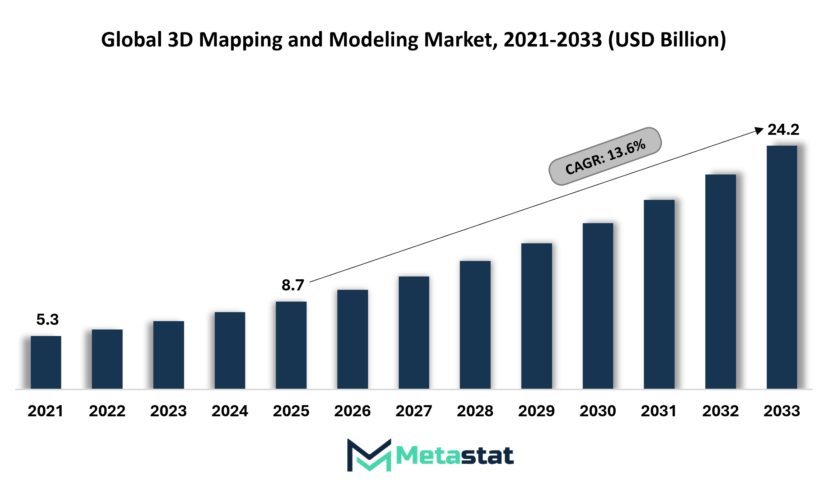
Increased adoption of geospatial intelligence and digital twin technologies across infrastructure and smart city projects.
Rapid urban expansion, transportation modernization, utility planning, and industrial asset tracking are increasing the need for precise spatial data and high-resolution 3D geospatial models. Digital twin platforms support predictive maintenance, traffic flow planning, energy optimization, land management, and infrastructure performance monitoring. Geospatial intelligence improves decision quality, project scheduling, cost control, asset visibility, and long-term operational efficiency.
Growing use of 3D visualization in construction, engineering, and autonomous navigation systems
Construction planning, plant layout, route simulation, and machine guidance increasingly rely on immersive visual models to improve accuracy and coordination. Engineering teams gain stronger clash detection, design validation, workflow coordination, and project risk reduction through 3D visualization tools. Autonomous mobility systems require detailed road geometry, obstacle recognition, and lane-level mapping to support safer navigation and route intelligence.
High cost of data acquisition technologies such as LiDAR and advanced imaging systems limiting adoption
LiDAR scanners, aerial survey systems, drones, high-resolution cameras, and supporting software require significant capital investment. Maintenance costs, calibration requirements, storage infrastructure, and skilled workforce expenses add financial pressure for adopters. Smaller organizations frequently delay deployment plans, slowing wider commercial adoption across price-sensitive regions.
Complexity in data processing and lack of standardized formats affecting interoperability
Large datasets generated from multiple sensors create complex workflows involving cleaning, alignment, rendering, processing, validation, and continuous updates. Inconsistent file formats and data structures reduce compatibility across engineering, transportation, defense, utility, and planning platforms. Delayed integration increases project timelines, operating costs, data silos, and collaboration barriers among stakeholders.
Expansion of smart city initiatives and autonomous mobility ecosystems creating demand for high-precision 3D mapping solutions
Government-backed urban programs connected transport corridors, intelligent parking networks, and automated logistics hubs are creating strong revenue potential for high-precision 3D mapping providers. High-precision mapping supports real-time monitoring, dynamic routing, public safety planning, emergency response, and infrastructure upgrades. Long-term contracts will emerge across municipal corporations, fleet operators, infrastructure agencies, and technology providers.
The Global 3D Mapping and Modeling Market is segmented by component, type, application, end user, and region.
Hardware segment is valued at USD 3.6 billion in 2026 and is projected to reach USD 8 billion by 2033, at a CAGR of 12% during the forecast period.
Advanced scanners, LiDAR devices, drones, depth cameras, edge processors, and immersive capture devices will drive higher precision across commercial surveys, urban planning, mobility testing, infrastructure mapping, and site inspection. Declining sensor costs, improved battery performance, and compact device design will support wider commercial deployment across developed and emerging economies.
Software segment is valued at USD 3.7 billion in 2026 and is projected to reach USD 9.8 billion by 2033, at a CAGR of 14.8% during the forecast period.
Cloud platforms, digital twin suites, rendering engines, spatial analytics tools, and AI-driven reconstruction software will expand operational value across 3D workflows. Faster processing, automated correction, and real-time collaboration features will improve workflow speed for organizations seeking accurate visual assets, predictive planning support, and connected data environments.
Services segment is valued at USD 2.6 billion in 2026 and is projected to reach USD 6.5 billion by 2033, at a CAGR of 14% during the forecast period.
Consulting, deployment, maintenance, managed operations, training, and customization services will remain vital for organizations adopting spatial technology programs. Adoption will increase among enterprises requiring legacy system integration, workforce readiness, security controls, and scalable implementation roadmaps linked to measurable business outcomes.
3D Mapping segment is projected to reach USD 12.2 billion by 2033, at a CAGR of 12.9% during the forecast period.
Urban planning agencies, mining operators, agriculture firms, and logistics networks will increase the use of terrain capture and geospatial intelligence. Rich location layers, route optimization, hazard detection, and infrastructure monitoring will strengthen planning accuracy while reducing field delays, manual surveys, and repeat site visits.
3D Modelling segment is projected to reach USD 12 billion by 2033, at a CAGR of 14.4% during the forecast period.
Product design teams, architects, surgeons, educators, and media studios will rely on realistic digital models for simulation, planning, training, and visualization. Advanced physics engines, material libraries, and AI-assisted model generation will shorten design cycles while improving accuracy, personalization, and immersive presentation quality.
Projection Mapping segment is projected to reach USD 2.9 billion by 2033.
Retail launches, public events, museums, hospitality venues, and branded experiences will adopt projection mapping systems for dynamic storytelling. High-brightness devices, synchronized motion control, and responsive content engines will create stronger audience engagement while opening new revenue channels for event organizers and creative agencies.
Texture Mapping segment is projected to reach USD 4.7 billion by 2033.
Gaming studios, industrial designers, e-commerce sellers, and training platforms will use texture mapping to create realistic surfaces and stronger visual depth. Automated material scanning, faster GPU workflows, and higher-resolution assets will improve realism standards while reducing manual editing workloads across production pipelines.
Maps and Navigation segment is projected to reach USD 7.9 billion by 2033.
Smart mobility systems, delivery fleets, tourism platforms, and municipal transportation networks will rely on richer navigation layers. Indoor guidance, lane-level detail, hazard alerts, and live route updates will improve travel efficiency while supporting autonomous mobility and connected urban infrastructure planning.
3D Rendering and Visualisation segment is projected to reach USD 8.7 billion by 2033.
Real estate marketing, engineering reviews, surgical planning, and virtual commerce will benefit from photorealistic visual outputs. Faster processors, remote rendering farms, and interactive viewers will enable persuasive presentations, quicker approvals, and stronger stakeholder understanding before physical execution begins.
Entertainment and Media segment is projected to grow at a CAGR of 13.3% during the forecast period.
Film production houses, streaming creators, broadcasters, and game publishers will expand the use of digital sets, animated assets, and immersive scenes. Production efficiency, lower reshoot costs, and richer audience experiences will encourage sustained spending across global content ecosystems.
Healthcare segment is projected to grow at a CAGR of 14.5% during the forecast period.
Hospitals, diagnostic facilities, research labs, and medical schools will adopt spatial imaging for surgical rehearsal, anatomy education, prosthetic design, and treatment planning. Precision gains, clearer clinical communication, and patient-specific modeling will strengthen outcomes while supporting advanced care pathways.
Building and Construction segment is projected to grow at a CAGR of 13.1% during the forecast period.
Developers, architects, contractors, and facility managers will use spatial models for planning, clash detection, progress monitoring, and maintenance forecasting. Waste reduction, budget control, and stronger schedule visibility will improve project delivery across residential, commercial, industrial, and public infrastructure applications.
Automotive and Transportation segment is projected to grow at a CAGR of 14.2% during the forecast period.
Vehicle manufacturers, rail operators, aviation firms, and logistics providers will use digital models for prototyping, route planning, warehouse flow optimization, and autonomous guidance. Stronger safety validation, fuel savings, and predictive maintenance value will increase investment across transportation networks.
Defense and Security segment is projected to grow at a CAGR of 13.5% during the forecast period.
Military planners, border agencies, emergency response teams, and surveillance operators will adopt advanced mapping for mission rehearsal, terrain awareness, asset tracking, and threat analysis. Secure data layers, rapid updates, and realistic simulations will improve readiness across complex operational environments.
Based on geography, the Global 3D Mapping and Modeling market is divided into North America, Europe, Asia-Pacific, South America, Middle East, and Africa.
North America leads the 3D Mapping and Modeling Market, supported by strong defense spending, infrastructure digitization, advanced enterprise adoption, and early use of geospatial intelligence platforms.
Europe represents a mature and technology-driven region in the 3D Mapping and Modeling Market, supported by strong adoption across infrastructure planning, smart city development, transportation, construction, and industrial automation.
Asia-Pacific presents significant opportunities for the 3D Mapping and Modeling Market, supported by rapid urban development, industrial automation, infrastructure expansion, and growing smart city projects.
Across the Middle East, Africa, and South America, the 3D Mapping and Modeling Market is progressing through infrastructure upgrades, mining applications, renewable energy projects, urban development programs, and improving digital survey capabilities.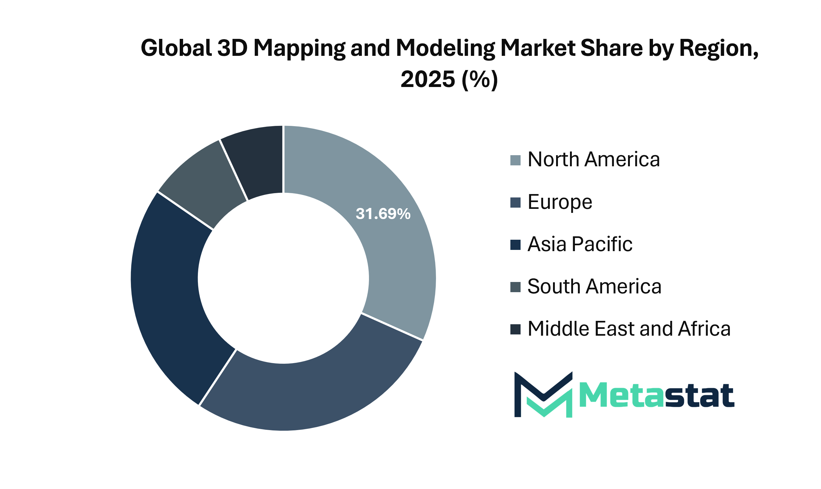
The Global 3D Mapping and Modeling Market continues to expand as cities, developers, infrastructure owners, and transportation agencies require accurate digital representations of land, roads, buildings, utilities, and physical assets. Advanced sensors, cloud storage, AI-enabled processing, and faster computing platforms are making 3D models easier to create, update, analyze, and share. Firms use these tools to plan projects, reduce rework, monitor progress, improve collaboration, and support remote inspection. Public agencies also rely on mapped data for safety planning, traffic management, utility operations, emergency response, and infrastructure monitoring. Adoption is increasing as organizations prioritize accurate spatial data that saves time, reduces errors, improves asset visibility, and supports smarter operational and strategic planning across industries.
Leading suppliers shape market development through software platforms, imaging technologies, field devices, spatial analytics, and integrated geospatial workflows. Autodesk, Inc. supports design and visualization workflows, while Bentley Systems, Incorporated serves infrastructure owners through engineering, digital twin, and asset lifecycle solutions. Hexagon AB, Leica Geosystems AG, and FARO Technologies, Inc. provide scanners and measurement systems that capture precise spatial environments. Trimble Inc. and Topcon Positioning Systems, Inc. help survey crews improve field productivity, positioning accuracy, and outdoor mapping efficiency. Environmental Systems Research Institute, Inc. (ESRI) remains a major provider of GIS and spatial analytics platforms used by planners, utilities, governments, and enterprises. Google LLC, HERE Global B.V., and TomTom N.V. support navigation databases and location intelligence platforms used across logistics, mobility services, fleet operations, and consumer navigation applications.
Other companies focus on advanced visual detail and industry-specific use cases. Dassault Systèmes SE and Oracle Corporation connect model data with enterprise systems, simulation platforms, and operational workflows. Maxar Technologies Holdings Inc. and Airbus SE supply satellite imagery and geospatial intelligence for planning, monitoring, mapping, and asset assessment. Nearmap Ltd, EagleView Technologies, Inc., and Vexcel Imaging GmbH support property analytics, aerial imagery, insurance assessments, and infrastructure inspection. Matterport, Inc. enables indoor digital twins and virtual tours for real estate, sales, facility management, and property documentation. Pix4D SA, DroneDeploy, Inc., and Agisoft LLC convert drone imagery into actionable maps and models for agriculture, mining, roofing, construction, and site inspection teams.
New entrants and niche technology firms are strengthening competition through specialized LiDAR, drone mapping, mobile capture, and processing solutions. Aerometrex Limited, Intermap Technologies Corporation, Ouster, Inc., Quantum-Systems GmbH, GeoCue Group, Inc., Propeller Aero Pty Ltd, NavVis GmbH, and SimActive Inc. provide specialized solutions across LiDAR, drones, mobile mapping, aerial imaging, and high-speed processing. Buyers typically compare accuracy, service quality, training support, integration capability, data security, and update cycles before selecting a solution provider. The market outlook remains positive as government and enterprises seek trusted digital representations to manage assets, reduce delays, improve planning, and strengthen operational resilience. Strong demand will favor vendors that deliver accurate, reliable, interoperable, scalable, and cost-efficient solutions for users across global industry verticals.
Market size is forecast to rise from USD 8.7 billion in 2025 to over USD 24.2 billion by 2033.
The Global 3D Mapping and Modeling Market is expected to become increasingly important across asset intelligence, simulation, digital twin, infrastructure monitoring, and machine navigation environments. Real-time digital twins are expected to support maintenance forecasting, emergency planning, asset optimization, climate resilience, and urban infrastructure strategies.
This research report categorizes the 3D Mapping and Modeling market based on key segments and regions, forecasts revenue growth, and analyses trends in each submarket. The report analyses the key growth drivers, opportunities, and challenges influencing the 3D Mapping and Modeling market. Recent market developments and competitive strategies such as expansion, product launch, partnership, merger, and acquisition have been included to draw the competitive landscape in the market.
The report strategically identifies and profiles the key market players and analyses their core competencies in each sub-segment of the 3D Mapping and Modeling market.
|
Report Attributes |
Details |
|
Study Period |
2021-2033 |
|
Base Year |
2025 |
|
Estimated Year |
2026 |
|
Forecast Period |
2026-2033 |
|
Historical Period |
2021-2025 |
|
Growth Rate |
CAGR 13.6% from 2026 to 2033 |
|
Revenue Unit |
USD billion |
|
Segmentation |
By Component, Type, Application, End-users, and Region |
|
By Region |
North America (By Component, Type, Application, End-users, and Country)
|
|
Europe (By Component, Type, Application, End-users, and Country)
|
|
|
Asia Pacific (By Component, Type, Application, End-users, and Country)
|
|
|
South America (By Component, Type, Application, End-users, and Country)
|
|
|
Middle East and Africa (By Component, Type, Application, End-users, and Country)
|
Find answers to common questions about this report
Top players operating in the 3D Mapping and Modeling industry include Autodesk, Inc., Bentley Systems, Incorporated, Hexagon AB, Trimble Inc., and Environmental Systems Research Institute, Inc. (Esri).
North America region dominates the market.
Global 3D Mapping and Modeling market is estimated to reach USD 24.2 billion by 2033.
High cost of data acquisition technologies such as LiDAR and advanced imaging systems limiting adoption will hamper the market growth within the forecast period.
The 3D Mapping is the leading type segment in the Global market.
Increased adoption of geospatial intelligence and digital twin technologies across infrastructure and smart city projects and Growing use of 3D visualization in construction, engineering, and autonomous navigation systems are key driving factors, boosting the market.
The Metastat Insights analysis shows that the North America 3D Mapping and Modeling market size is estimated to be USD 7.2 billion by 2033.
The Global 3D Mapping and Modeling market is expected to grow at a CAGR of 13.6% over the forecast period (2026-2033).
The Metastat Insights study shows that the Global 3D Mapping and Modeling market size was USD 8.7 billion in 2025.
The analysts below cover Information & Technology research at Metastat Insights.
LEAD ANALYST
Utkarsh Khirodkar is a Lead Market Research Analyst at MetaStat Insight, specializing in market intelligence, technology sector assessments, and competitive strategy.

PRINCIPAL CONSULTANT - ENTERPRISE AI & EMERGING TECHNOLOGIES
Banking & Finance · Electronics and Semiconductor · Energy and Power · Healthcare IT · Information & Technology · Professional Services
Vijay Gunti is a Principal Consultant at MetaStat Insight, bringing over two decades of experience across enterprise digital transformation, technology strategy, and intelligent systems.

LEAD CONSULTANT - COMMUNICATION, TELECOM, AND IT
Electronics and Semiconductor · Information & Technology · Machinery & Equipment · Professional Services
Ravindra Sathe Consultants for Communication, Telecom, and IT at MetaStat Insight. He leads the firm's industry research initiatives across telecommunications infrastructure, digital connectivity, enterprise networking, and emerging information technology domains.
Our team was tracking whether regional recycling infrastructure could realistically absorb the growing volume of lithium iron phosphate batteries over the next decade. The report did a solid job separating announced hydrometallurgical plant capacity from active, permitted operational throughput. That distinction made the feedstock availability projections and regional recovery rate models far more credible than standard commercial overviews.
Tracking capacity expansion in single-use bioprocessing requires dependable data on raw material availability and cleanroom-grade polymer supply chains. The competitive landscape chapter gave a grounded evaluation of secondary component suppliers across North America and Asia-Pacific rather than simply reprinting press releases. Having that level of supplier benchmarking helped clarify dual-sourcing considerations for our clinical pipeline planning.
When evaluating distributed energy resource management systems, standard research summaries tend to gloss over the operational differences between front-of-the-meter utility deployments and behind-the-meter industrial sites. The MetaStat Insight report addressed those distinctions directly, especially regarding software interoperability standards and grid interconnection backlogs. The five-year market sizing across regional transmission organizations provided actionable context for our grid modernization strategy.
Explore related market intelligence reports worth reading alongside this one.